


The Backcountry Discovery Routes (BDRs) are a network of off-road oriented trails that travel through some states in the United States. At the time of this trip, there were were trails in Arizona, New Mexico, Utah, Idaho, Colorado, Oregon, and Washington.
The trails are designed so that a heavy adventure bike can ride through them and experience a multi-day adventure that is often full of history, backroad challenges, beautiful scenery, and an opportunity to get away from the crowds for a little while.
It’s our time to do the Arizona route – known as the AZBDR. We’ve got two weeks.
AZBDR Trip – Preparation
Let’s put this out there… We are NOOBS. Motorcycle noobs. Just last year, we purchased our first motorcycles – a pair of used BMW G650GSs. We affectionately call them our “mules” because they pack us and our junk around and don’t complain about it.
The GS name refers to Gelände/Straße (German for off-road/road). Basically these bikes are the result of what would happen if a papa dirt bike impregnated a momma touring motorcycle. They are tough bikes designed for traveling around the world but are also a bit on the heavy side. More on this later… the deep sand later…
Our motorcycle training consisted of completing the initial and intermediate MSF motorcycle safety classes and a day-long course designed to get you familiar with riding off-road, on uneven terrain, and a little taste of sand. Sand, ugh.
After weeks of looking at different option we finally went with renting a trailer for getting the mules and our stuff to my Sister-in-Law’s home at Coolidge, AZ. Riding the bikes there would have been an option but we also needed to get our 17-year-old son and his school stuff to AZ. Poor dude, he had the ‘joy’ of doing home-school while his parents toured Arizona via adventure bikes. There is a lesson in responsibility in there somewhere. 😂

The mules all loaded, strapped down, and ready for transit from San Diego, California.


Saw this guy on the I-8. This guy knows how to pack a truck! Well done my friend 👍. Not sure if I would follow him though, especially on a motorcycle 😬!
We arrived that evening in Coolidge, AZ and had a good time with family. I forced myself to get some sleep even though I was a bit excited and nervous about the next couple weeks. I hoped all the planning and preparing had paid off. Did we forget anything?
AZBDR – Day 1 of 11
🗓: 23 Apr | 🌍: Coolidge to Sonoita, Arizona


Map of Day 1: 195 miles paves + 45 miles dirt = 240 miles total
The bikes were unloaded and all the luggage was separated and organized


How is ALL this stuff going to fit on two bikes?


All packed up! The mules are rearing to go.
We left Coolidge, with the incredible send-off and support of our family, and made our way to Tombstone via the I-10 and SR80.
The Wild West Town of Tombstone, Arizona
Tombstone was fun but it really is a tourist destination. There are shops, restaurants, shows, and carriages all competing for your money. Not that this is a problem normally, but when it’s all contained within a small town like Tombstone it was a bit too much. We found a quite restaurant called Café Margarita where we enjoyed some delicious fish tacos. Highly recommended.


Just hanging around Tombstone.


Our mules look better and eat less!


Beautiful horses and carriages.

Old prospector character in faded hat and pink shirt.
Arizona Backcountry Discovery Route
After lunch it was time to hit the road and make progress for our reason for visiting Arizona – the BDR. We took East Charleston Road to SR92 and then entered the official start of the AZBDR at Coronado National Memorial.

Welcome to the AZBDR! The official start of the long and exciting road ahead. Within a short period you are in the dirt and making the climb to the overlook.

The mules look much better on the dirt.

The views from the top are good ones. Looking East…

…and looking West.
A little detour from the main trail takes you to the border of Mexico. Although this section is only about a mile, it was one of the highlights of the day.
As I was descending a steep hill near the border I remember thinking how great it would be to do the whole 750ish miles without dumping the bike. As I contemplating my awesomeness and skill I grabbed to much front brake, skidded the front tire, and dumped it. It was my first of many times I dumped the mule. Sorry Apache (name of my bike)!

The mule and the US/Mexico border.

A fence designed to keep Mexican cows from coming and eating USA grass.

The prairie land that we passed though was beautiful and remote. We didn’t come across a single soul until just before reaching Sonoita.
We stopped for some chow (New York Steak and potatoes) at The Steak Out in Sonoita.


Old school motorcycle rider. Those old school motorcycles used A LOT of hay and water!
We continued up the trail north to East Yucca Farm Road where we found a nice quite spot among some antelope and set up camp for the night. If only we had a guitar… and someone who knew how to play it.

Sunset over the prairie. Makes me want to sing “Home on the Range”.
AZBDR – Day 2 of 11
🗓: 24 Apr | 🌍: Coolidge to Redington, Arizona

![[IMG]](https://i0.wp.com/farm8.staticflickr.com/7392/26278332363_811eab20b8_o.jpg?w=674&ssl=1)
Map of Day 2: 45 miles paved + 36 miles dirt = 81 miles total
We woke to the sounds of a bunch of whelping coyotes. As we were folding up our tent a truck and horse trailer drove by and we exchanged friendly waves. We were on the road by 7:00 and had planned for this to be a light day of no more than 80 miles. It turned out to be anything but a light day…

Apache roaming the plains of Arizona.

GoPro fun on the trail.

In general the first part of today’s trail was easy going but rutted. But then we came to a section where the map offered a bypass to those not wanting to brave the deep sand.
I figured I offer this choice up to my mule Apache. We placed him on the center stand and asked him to blink in the direction he wanted go…

As you can see from the turn signal, the answer was to the right. Right into the sand. Apache, what were you thinking?
Along the way, we ran into EJ’s Summer Home. It looks like EJ likes to shoot shotguns into his summer home and it definitely improves the ventilation.

It was full of holes but made for a cool picture of our bikes parked outside.
Once we hit the sand, the real work began. I can’t remember how many times we dumped those mules. It was a lot. I was getting quite frustrated with the sand. In my frustration I missed a turn-off to the left that climbed a steep hill. This mistake made us both endure another 1/3 miles of sand.

A still of the video documenting the many times I dropped Apache in the sand. Chantil had an equally hard time.

Even though it was a tough day, we still took time to smell the desert flowers

We came across these huge water tanks that were being pumped by the windmill. I was almost hot enough that I considered taking a swim in the tank but decided against it out of respect for the owners that were letting us travel through their property.

After the sandy section the road was much easier traveling.
After reaching pavement, we made a quick check of the mules before hitting the fast pace of the freeway towards Benson.

The 650s are adequate on the freeway but not fast. Here we are getting dusted by a large tractor trailer.
In Benson, we gassed up at Love’s Truck Stop and then rode across the street to the Taco Bell where we had some early dinner at one of the outside tables under the shade.

Now this is the Arizona I expected.
We found the perfect camp site – protected from the view of the road by a large rock formation. That evening we enjoyed a bit of the surrounding beauty before dark set in and we fell asleep under the vastness of a billion stars.
Continued on PAGE 2…
AZBDR – Day 3 of 11
🗓: 25 Apr | 🌍: Redington to Pioneer Pass, Arizona

Map of Day 3: 23 miles paved + 59 miles dirt = 82 miles total
The sun crept into the tent at about 5:30AM causing me to wake and discover that I had the perfect view of our mules waiting outside the tent.

The mules are excited and ready for another day of riding.

We took our time to explore around the campsite for a little while before packing up the mules for the next section of trails.

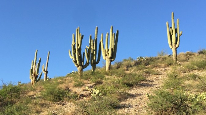
We don’t get to see a lot of Saguaro Cactus where we live so I am amazed at the size and shapes of these amazing species.

Chantil enjoying breakfast.

Shortly after hitting the trail we came across the ‘famous’ three-tire cactus. At least is seemed famous to us since it was highlighted in the AZBDR trailer and movie.
A little later we came across a snake in the road. A previous vehicle had hit it and it was laying dead…

…so we coiled it up to look more menacing so we could…

…film us and the snake via the GoPro!
After playing with the dead snake, we continued north where we played with the selfie stick…
…while riding a motorcycle…
…off-road…
Probably not my brightest decision but the results were pretty good.

Motorcycle selfie
We continued onward towards Mammoth where we topped off our water, fuel, and enjoyed some delicious breakfast burritos at Las Michoacanas Mexican Restaurant.

The mules parked at Mammoth, AZ.
We continued north for only a short section of pavement before turning left on Camino Rio Road where we followed a train track access road that featured fun whoops and some little hills climbs to enjoy.

Exploring train tracks…

…ant piles…

…and old abandoned church buildings.
After a little while it was time to hit the pavement, which was a nice break from the heat. It wasn’t to long before we were back in the dirt after turning onto Dripping Springs Road. This section of the road was a bit more challenging because of the hills. Large rocks were also thrown about the trail to keep things interesting.

Chantil tackling one of the hill climbs, littered with ruts, and large rocks.

This particular section of trail was giving us a bit of anxiety because we had read an update on the AZBDR website where there was a large section of trail that was severely rutted. I had plotted this section on my GPS. We continued up the trail without seeing anything that was described in the update. Maybe the author’s definition of heavily rutted was much different than ours? Maybe we are just so awesomely experienced that we just rode right up the hard stuff? Just about as we were to pat ourselves on the back we came across the heavily rutted section.


Boy was it! It was a challenge to get both bikes up without dropping them, but somehow we managed it and were grateful once we got through that section! I provided an update to the AZBDR folks via email so hopefully others won’t have to endure the anxiety we faced.

We decided to stop for the day at the Pioneer Pass Campground where we had the entire campground ALL to ourselves. It was a bit cooler so we set up the entire tent with rain cover in the hopes that we wouldn’t be as cold throughout the night.
AZBDR – Day 4 of 11
🗓: 26 Apr | 🌍: Pioneer Pass to Somewhere? in Arizona

Map of Day 4: 27 miles paved + 49 miles dirt = 76 miles total
Today was a short and long day. Short distance. Long hours. The trails were filled with rocks and included long sections of hills and descents. It was a challenge. Tempers were lost. Bikes were dropped. Bikes were broken and fixed on the trail. It was an “adventure”.
Getting to Globe was pretty straightforward. The trail leaving Pioneer Pass Campground was wide and graded. Once in globe we stopped by the grocery store and stocked up on trail food. We had a cold cereal breakfast at a nearby park under the view of the large orange “G” painted on the side of the hill overlook the city.


Entering Tonto National Forest.
After a relaxing breakfast, we continued north until reaching our next off-road section at Cherry Creek Road.

The lower part of Cherry Creek Road.
The beginning of the trail featured a lot of high desert cactus and cliffs. As we continued our climb we became surrounded by thick green trees, gently rolling creeks, and rocks. Lots of rocks. So many rocks. Rocks of all sizes and shapes. Stupid rocks.

Entering the beautiful Sierra Ancha Cliff Dwellings area.
This section offered beautiful scenery at every switchback making it a challenge to concentrate on the rock-filled trail.

Beautiful cliffs tower above the trail.

For lunch we stopped at a great little shaded area. A lunch of champions!
We talked a bit to a guy who drove a Toyota Tacoma. He was enjoying the solitude along with his two dogs. He mentioned that it had been a decade since he drove up here last and was surprised at how rocky the road had gotten.
During our break we fixed a few things on the bikes. Chantil’s left foot-peg and left hand-guard had taken a beating while being dropped on the rocky trail. In caveman style, I grabbed a rock and hammered the foot-peg until it was level.

We also fixed the broken hand guard by drilling a few holes (using a Gerber tool) into the plastic and using a trusty zip-tie to keep it in place.
It was just after lunch that I lost my cool. It was hot. We were struggling to get through the relentless rocky sections, and Chantil had dumped her mule and broken the zip-tie fix. Kudos to Chantil for dealing with me. She’s awesome and I’m grateful to her for letting me vent.

Big rock in the road! So many rocks on this portion of the trail!

Moo Cow looking rather agitated at the mechanical mules. My bike is bright red so I was a bit nervous that one might charge!! A twist of the throttle kept him in line.
Just before reaching AZ-288 we found a pasture area that looked like it had previously been used as a campsite.

Camp fire!
This was our first night where we had a camp fire and it felt GREAT; especially after such a long day of climbing rocky roads. The Mountain House Mexican Style Rice & Chicken was more delicious than you could imagine.
Continued on PAGE 3…
AZBDR – Day 5 of 11
🗓: 27 Apr | 🌍: Somewhere? to Flagstaff, Arizona

Map of Day 5: 32 miles paved + 128 miles dirt = 160 miles total
The trail from our campsite got much easier as he headed towards the AZ-288. I was expecting a paved road considering that highway designation. Turns out it is what they call a dirt highway. Okey doke!

Cows also use the wide open dirt road. I can’t recall how many cattle guards we crossed; maybe 50?

We are still in the Tonto National Forest, which seems to cover quite a lot of area considering the last sign was in the desert and now we are in the forest.
We reached the small town of Young where hospitality was large; seems to be the case with small towns. We ended up hanging out in front of the Cherry Creek store where we ate a cheap brand of Fruity Pebbles cereal out of camp cups with fresh milk from the store.

The joys of life on the road!
After Young, we continue north along the beautiful Mogolonn Rim. I was really surprised at how little tourist traffic there was on this section of the road, considering the beautiful overlooks off to the west.

Beautiful overlooks down to the Colorado Plateau.

Scary fall to my death! This is a picture where it looks worse than it is in real life.

An opportunity to take a group shot of us and the mules.
The trail continued north where the easily-traveled road made for some quick riding; we even shifted into fourth gear for some straightaway sections!

Coconino National Forest. The trees became larger and denser as we continued north.
On one of the fire roads we came across a building used by the forest service. It had a nice picnic table so we parked the mules and enjoyed a little lunch.

First break-down of the trip! The sporky-knifey thing broke on the thick peanut butter.
Before long we heard the distinct sounds of a couple thumpers heading our direction. This was the first time we had ran across anyone on adventure bikes. It turned out to be Pascal and Janine from Switzerland. They are a 25-year-old couple who shipped their DR650s to Canada and were exploring the USA. Someday we will travel full-time for more than six months… I promise you.
As we continued north, the forest turned to prairie land.

Some more GoPro images of us enjoying the trail
In the late afternoon just past Long Lake when we came across three guys riding 1200GSs. They were on their way to Colorado and were enjoying the detour of the AZBDR.

I followed two of the pilots for some spirited rocky sections of the trail. It was a joy to push myself a little bit faster than my previous comfort level.
We made good progress until reaching Winona Ranch Road. The wide open trail became more challenging as it narrowed, become more rocky, and required numerous small hill climbs. Chantil’s mule was dropped hard enough on the rocks that the bolt holding the Bark-Buster hand guards to the end of the handlebar sheered. We removed the hand guard and continued along the trail hoping that she wouldn’t drop it on the, now exposed, left side. She didn’t!

Riding through Winona Ranch Ranch Road well after dark.
It was well after 9 PM when we reached the gas station in Winona. I was tired enough that I just wanted to set up camp behind the pumps and call it a night.

Topping off the tank in Winona.
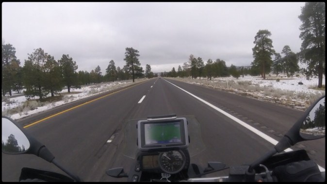
We found a hotel in Flagstaff but it required the traumatic experience of riding 9 miles at 80 MPH on a dark freeway with poorly adjusted driving lights (from being dropped on the trail). There is something about riding freeway speed after being on the trail all day that just feels weird. It’s hard to explain.
I hate paying for hotels, especially when traveling because you end up paying a premium for the simple pleasure of a bed and shower. However, I was overjoyed to reach the Super 8 Hotel where we could take a little break from the trail and get some things fixed before continuing north.
AZBDR – Day 6 of 11
🗓: 28 Apr | 🌍: Flagstaff to the North of Coconino National Forest, Arizona

Map of Day 6: 13 miles paved + 54 miles dirt = 67 miles total
I slept really well last night. There is just something about sleeping on a mattress that makes me just sleep better. After 4 nights of camping a hotel felt really good.
It’s not as if our camping sleep system is uncomfortable. If fact, I think it’s one of the most comfortable systems available with a very roomy and wide 20º Big Agnes sleeping bag, a 25 inch wide insulated air mattress that slides into the bottom of the sleeping bag, and a felt-lined camp pillow. I just sleep better on a real mattress.
We enjoyed the complimentary continental breakfast before we headed our separate ways to run some errands. Chantil went to find a garage that would help her tap out the broken bolt that was inside the threads of her handle bar. I went to find another bolt to replace the one that had sheared. I also went in search of a camping goods store to find a small MSR fuel bottle (forgot at home) and some synthetic long johns to wear under my motorcycle pants in preparation for the expected rain and cooler weather.

Broken bolt that held the hand guard to the end of the handle bar.
We were able to get Chantil’s hand guard fixed relatively quickly allowing us to pack the bikes and continued the BDR well before noon.


The weather report was a concern since the trails we were going to be riding were listed as ‘impassable when wet’. The rain looked like it would make things wet. We hoped for the best…
Shortly after passing north of Winona we were approached behind by the three 1200GS riders we met the day prior. The lead rider introduced himself as Paul. We talked about the concerns we had about the upcoming rain. They waved their good wishes and goodbyes before rolled ahead of us and over the horizon.

It seems everyday offers something different on the AZBDR.
Today was no different as we got to explore cinder cone volcano country. The roads were somewhat of a cross between gravel and course sand. It was fairly easy traveling, as long as you watched out for the sandier sections.

Enjoying the volcanic gravel roads.

You can see the consistency of the volcanic gravel on the road.

Riding through volcano country.

We stopped at the overlook of Sunset Crater Volcano for a short break.


See that. That’s not good weather for riding on roads that claim to be ‘impassable when wet’. How bad could it really be?
We continued north for as long as we could before we reached the clouds that continued to look more and more grey. We decided that we would rather set up camp before things got wet so we pulled off the road about a ¼ mile and set up camp.

All cozy in our warm and comfortable tent awaiting the impeding rain.
It wasn’t until about 4 AM the next morning that the rain arrived. We should have camped closer to pavement…
Continued on PAGE 4…
AZBDR – Day 7 of 11
🗓: 29 Apr | 🌍: North of Coconino National Forest to Flagstaff, Arizona

Map of Day 7: 68 miles paved + 6 miles dirt = 74 miles total
As soon as I stepped outside of the tent in my sandals I knew it was going to be a wet and muddy day.
We quickly packed up in the hopes to get an early start on the trail and hopefully avoid too much mud. Packing the tent went much better than I imagined since the ground we slept on stayed relatively dry and we were able to get most of the water off the rain cover before packing it.
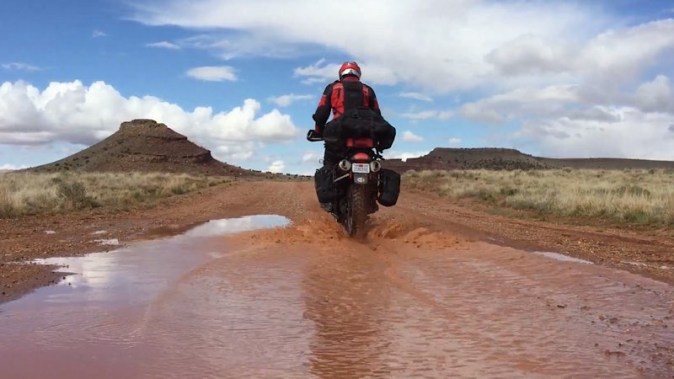
Although the going was muddy and sometimes a bit slippery, I still felt like we could make progress along the AZBDR route towards Cameron, AZ.

My Sertao was making decent progress as long as I kept the wheels spinning fast enough to throw the mud from the treads.
However, if you got bogged down or started to slide then it became very, very difficult to get started again.

Chocolate donuts make for extremely poor traction.
Chantil was having an especially hard time. I just told her to keep on the speed and things would go better. However, she said she couldn’t because the front would slip around. I parked my mule and gave hers a ride. She was right, her bike is about 1.5 inches lower and has a fairing that sits really close to the top of the front wheel. It was extremely difficult to control and keep straight. I had to give it A LOT of power to keep it moving. Further investigation showed that the front wheel would not turn! The clay like mud was packed so tightly in the front fender that the front tire would just push through the mud. The rear was also packed so full that the poor 650 engine could barely turn the rear wheel. We decided to get off the trail as fast as we could.

Mud was on everything!
The highway was about 3 miles from the AZBDR route. Progress was excruciating slow because we would move a little, drop the bikes, clear the wheels and fenders of mud, and then move a little more. We removed Chantil’s front fender and it seemed to make things go a little easier.
Picking up the mules started to become A LOT of work. We continued little by little, the 6 miles we covered took us about 3.5 hours. The hardest section was the last mile. It was exhausting. Hope was driven by the GPS slowly counting down our progress to the highway.

We made it to PAVEMENT!! I’ve never been so happy to see pavement! We were wet, muddy, and tired.
We decided to head north along the US-180 to the SR-60 where there was gas and hopefully a self-serve power wash for the muddy mules. The rain had stopped before we reached the Chevron station. My clothes were so muddy I was concerned that they wouldn’t let me into the touristy store to use the bathroom. I ended up washing my gloves and boots in the sink; earning me a few weird stares from tourists.
I really just wanted to get the bikes cleaned up. It was decided to return to Flagstaff where the closest pressure washer and reasonable priced hotels were. I would later regret this decision, but at the time it seemed like the right one.
So back we rode, via the US-180 to Flagstaff. During that 50-mile stretch of pavement we experienced sun, rain, sleet, and a little snow.

This section of road could easily be confused for Colorado. Nope, still in Arizona.
Once we arrived at the hotel in Flagstaff, we removed all the muddy bags from the mules and stored them in the bathroom until we could wash them in the tub. It was a mess. There was soooo much mud. If the mud were a red color, it would have looked like a murder scene in the bathroom and shower. Fortunately, it cleaned up pretty well. We also removed all the armor from our riding gear and tossed them in the washer. It took two cycles in the washer before they came clean.
We ended up staying in Flagstaff over the weekend since we had family that was passing through and thought it would be a nice place to have them layover for an evening.
Stuck in Flagstaff
🗓: 30 Apr | 🌍: Flagstaff, Arizona


I feel like a caged animal. I want to get on the trail and continue the route but rain is making the dirt roads nearly impossible to travel. We’ll just have to wait. Not happy.
We ran a few errands around town to include:
• Power-washing both mules at the self-serve car wash.
• Buying a new taillight bulb for Chantil’s mule.
• Ordering a catered tray of delicious Chick-fil-A nuggets.
• Topping off our camp food at the grocery store.
They are expecting snow tomorrow in Flagstaff! Snow in May…
Stuck in Flagstaff
🗓: 1 May | 🌍: Flagstaff, Arizona
Snow! We woke up to snow this morning. Not a lot, but enough to make us feel bad for having to leave our mules outside in the uncovered parking lot. Poor guys, but the hotel has a strict no mules in the motel rule!
Two older gentlemen pulled in last night on their 1200GSs. Apparently they are from Canada and are on their way to Vegas. Despite the snow and cold, they suited up after breakfast and continued west. If we were traveling on pavement we would have left as well, but the trails will be extremely difficult in the wet mud.
We decided to enjoy the cool morning and walk ourselves to church services. It was nice to recalibrate my thoughts on more spiritual matters since I was a bit down in the dumps about being “trapped” in Flagstaff.


Guess where we are? We’re in the middle of the green and blue! It seemed to be nicer in every direction north, south, east, and west of Flagstaff!
On our way from church services we stopped at Bushmaster Park. The playground was especially enticing since it looked really new and modern. We ended up playing for quite a while before returning to the hotel. Swings and zip-lines are fun at any age!
That evening, part of our family arrived and we got to enjoy their company well into the night. We always have A LOT of fun when we reconnect with our family and it was great to see them once again. Great times!
Continued on PAGE 5…
AZBDR – Day 8 of 11
🗓: 2 May | 🌍: Flagstaff to Navajo Nation, Arizona

Map of Day 8: 62 miles paved + 100 miles dirt = 162 miles total
Monday morning brought a renewed energy! We were well rested, well supplied, and ready to make progress of our AZBDR adventure. I was also excited because this day was the one I had looked forward to since we learned of the AZBDR – Navajo Nation.
The morning was cold and still quite wet. The snow had cleared from the roads but still remained on the shaded and shoulder areas. I was grateful that I didn’t convince myself to forgo bringing my heavy adventure jacket and cold weather riding gear for this trip. That would have been a mistake.
We experienced climates that we never expected for Arizona in May.
As we continued north along the pavement the conditions became better with each mile. The road shoulder went from snowy, to wet and muddy, and then to dry. We were relieved that today would end up being much more enjoyable than our mud slug-fest we faced a few days ago. Things were looking up.
In Cameron, we stopped at the Navajo Visitors Center and purchased our Permits for $12.00 each. Believe me, this is WORTH EVERY PENNY, as you will discover from our pictures…

Navajo Permit granting 24-hour passage to hundreds of miles of wild-west roads! This is much better than a ticket to Disney Land for sure.

Look for the octagon shaped building. The gentleman who issued the permit gave us a warm greeting and was very helpful when we showed him the areas we wanted to explore from our Butler map.
A few miles north we got sucked into the Cameron Trading Post. We were looking for a Native American style rug that we could put in front our tent but didn’t want to spend too much.

There were magnets…

… and minerals…

… even coffee mugs…
Finally we found the rug we were looking for! It ended up being a placemat for the dinner table but it was perfect. We’ll have a picture of it later…
The intoxicating fever of consumption by the busloads of tourist got the best of me and I purchased a small dream catcher that I hoped would grant me some kind of favor as I traveled the Navajo Nation. Further research, after the trip, revealed that dreamcatchers originated from the Ojibwe people of Canada and Northeast United States. The Navajo probably find it to be an undesirable form of cultural appropriation.

Anyhow, there it is hanging from my GPS mount hopefully catching my dreams of not getting broke, bloodied, and busted-up from getting thrown from my mule.
Within a short while we were turning onto dirt. The roads were all wide and regularly leveled making for quick and effective travel.

There was a really cool (it actually was cooler inside) traditional home with stone walls and a wooden roof just off the main road that offered a short break.


Our German made G650GSs fit into the Navajo landscape flawlessly. At least I think they do.

Although the well-maintained dirt roads made travel quick, we seemed to take a lot of breaks because each corner revealed some really beautiful country.

Small mesas pushed upwards from the earth by tectonic activity and then weathered by differential erosion made for some breathtaking scenery.
For lunch we decided to drive the 5 miles to the overlook via Indian Route 6134. If you have the pleasure of traveling this area of the country then DO YOURSELF A HUGE FAVOR and ride out to this overlook. I find the Grand Canyon National Park to be an incredibly beautiful park but I also feel that it suffered from being way too commercialized. The Navajo Nation is one of the few areas you can still enjoy the similar majestic beauty WITHOUT the tourism.

Majestic cliff walls that give you a sense of vertigo as you approach their edges.

It’s unconceivable to me that a river shaped such an incredible canyon.

Two of the most beautiful things in my life; Chantil and Mother Earth.

A red motorcycles might be the third most beautiful 😜

The mules graze patiently waiting for us to take in the amazing views around us.

Desert flowers were in bloom and provided fresh life to contrast the harsh steepness of the cliffs on the horizon.

The quietness and beauty was invigorating.

A selfie of the two of us before we head south again to join the main route.
On our way back to the main trail I noticed about 4 miles from the overlook that I didn’t have my CamelBak. I quick search revealed that I probably left it back at the overlook spot. Dang. I hurried back to the overlook to find my…

… CamelBak right where it fell from my bike. It was just laying there… hoping that we would be magically reunited in a blissful hydrated embrace. I kid, but the CamelBak was really useful and I wouldn’t have done a trip like this without it.
Once we were back on the main trail it was smooth rolling.

Riding along the Indian Route 6134. Apparently the practice of shooting signs with a shotgun is alive and well in the Navajo Nation as well.


More beautiful mesas!
You think we would be smart enough to avoid mud after our experiences from three days ago. 😆

Apache, named after the red pony I rode as a little kid, in the Navajo Nation.

ADV Rider stickers look much better dirty.

More beauty as we continued north along the Indian Route 6133.
We had heard about a great place to camp for the evening from another fellow ADVRider convict. I plotted the waypoint and I knew how to get to it via the 14 mile Indian Route 6110. However, we noticed on the Butler Map that there was a shorter route from the north. We searched and searched riding around on some pretty isolated single-tracks. We even had enough cell-phone signal to search for a route via Google Maps but came up empty. The route on the Butler map is a “unicorn road” because, like the unicorn, it DOESN’T EXIST!
Although we were a bit frustrated with our search for the unicorn road it did offer us a chance to ride some less traveled trails.

We came across the remains of a dead horse or mule, which seemed to bring new life to the flowers that bloomed near the bleached skull.

I tried to convince Chantil that she should figure a way to mount the skull to replace the fender on the G650GS. She wasn’t convinced. I still think it would have been a cool modification.
We knew, from pictures, that the area we wanted to camp at was well worth heading the 25 miles back to the south. Gas was going to be an issue and we expected our low fuel lights to come on sometime tomorrow. Fortunately, we had about 50 miles each of spare fuel in the 1.75 gallon RotoPax. No problem.

Chantil taking a little nap as she leaves the role of navigating to the campsite to me.


We ended up getting to the overlook camp area (36º 24.244’ N 111º 50.055’ W) just after dark. That little blue dot is us on the majestic cliffs of the mighty Colorado River. Unfortunately, pictures of the campsite and the canyon will have to wait until Day 9…
AZBDR – Day 9 of 11
🗓: 3 May | 🌍: Navajo Nation, Arizona to Utah Border

45 miles paved + 62 miles dirt = 107 miles total
I awoke early because I was excited to capture an iPhone time-lapse of the canyon during the sunrise. The iPhone was fully charged, I found the perfect ledge for the tripod, composed the canyon within the camera frame, and then started the process just before the light began to peer into the canyon. It was going to be epic!!
NOT! I captured about an hour and a half of time-lapse, which made for a 30 second video. The problem was that the exposure was not preset so the iPhone auto exposed each image. The final product was terrible. I was a bit bummed because this was a one-time-only kinda thing. Oh well, I did get some good photos…


Sunrise silhouetting our campsite.

The campsite was so incredible and isolated. Right on the cliffside!

And here is the tent rug we bought the day before. It looks great next to the tent and my stinky motorcycle boots.

Warming up some water for a hot breakfast to suppress the chilly morning of about 40º F.


During our breakfast the canyon was splashed with rays of scenic sunlight.
The trail out of the campsite was a bit rutted with an 8-10 inch step made of sharp rocks. Last night we went down it; much easier with the help of gravity. This morning we would have to climb back up it. It was a bit technical but we both got up just fine. Had we tried to do an obstacle like that a week ago it would have been more of a challenge. Our off-road abilities were improving!


On the 14-mile leg back to the main route we passed by some beautiful flowers growing in the middle of the two-track trail.

The only shiny thing on my bike and I can’t even keep that clean. Oh well. A clean GS is a dirty shame.

It wasn’t too long after hitting the trail that our low fuel lights came on. Once the light comes on I underestimate about 50 miles before we’re empty. This was the longest we had gone without fueling the entire trip and gas was less than 35 miles away. All good! Besides, we also had 1.75 gallons of extra gas in the RotoPax.
We reached the pavement and continued north along the beautifully paved and isolated State Route 89A towards Marble Canyon.

The beautiful views and wonderfully paved roads provide a break from the dirt.

We stopped at Marble Canyon for some much needed gas, and water. I even chowed down on some convenience store nachos, which were surprisingly good. I think food taste better when you’re on the road. 😄
While leaving Marble Canyon I started to reflect on the entire trip and that it was coming to an end. Part of me really was bummed. I really didn’t want it to end. I wanted to continue through Utah, then Idaho, then through Canada all the way Alaska. I didn’t want to stop. We were about to turn north onto the very last section of dirt and I just wanted it to last forever. 😞

The last dirt section was marked by this sign for the Vermilion Cliffs.

The Vermilion Cliffs were quite beautiful.

Exploring an old, rustic cattle pen.

As the road continued north the beautiful and diverse sandstone scenery became more plentiful.

The GPS waypoint marks the Utah/Arizona border and the official end of the AZBDR. No there wasn’t a huge field of green grass on the Utah side as indicated on the GPS map.

We made it!! Utah or bust without any real busts (bikes or bodies). Celebratory jump for joy!
We took a small break and then found the Stateline Campsite where we parked our mules in Utah and then set up camp 20 feet away in Arizona. This was our first, and only, developed campsite that we stayed at during the entire trip and the cost was FREE!
Some may think that this is the end of the adventure… But fear not! Remember the mud from day 7? The near-zero progress forced us to forgo about 60 miles of the AZBDR. Tomorrow we plan on going back to complete that section from north to south. More to come…
Continued on PAGE 6…
AZBDR – Day 10 of 11
🗓: 4 May | 🌍: Utah Border to Coconino National Forest, Arizona

Map of Day 10: 128 miles paved + 69 miles dirt = 197 miles total
We woke up in Arizona, packed up the bikes, which were parked in Utah, and rode north along the dirt road of House Rock Valley. Once we reached the pavement of Hwy-89 we headed east where we passed Lake Powell and into the town of Page, AZ.
Breakfast, gas, and water (in that order) were our purpose for stopping. We found breakfast at the Canyon Crepes Café. It was a bit difficult to find because it’s tucked away in a back of a shopping area but its well worth it.

An excellent breakfast of crepes ensured our morning was off to a great start!

A beautiful mural of Japanese style Koi Fish was painted just outside the restaurant.
After topping off our gas tanks and water bladders. We continued south along the Hwy-89 to Cameron, AZ where we topped off the fuel tanks once again.

The newly built roundabout in Cameron. Roundabouts are fun to go-round-about! The center looked like it might have a Native American symbol or something painted on it but Google Earth doesn’t have the areal view yet.
Once we reached Grey Mountain, we left the highway to reclaim the section of road we bypassed a few days back.

Beautiful mesas populated the high desert scenery.
Indian Route 6150 required a fairly long and rocky climb up to the top of the ridgeline. We were grateful to be climbing this steep section of trail instead of descending it.
Once you reach the top of the ridge the road opens up and the trees, short of some small bushes, disappear from the landscape.

On the horizon we saw the only tree for miles. We parked the bikes in the shade and took a little break from the heat.

A single tree contrasts the miles of open prairie.

Chantil relaxes in the cooler temperature of the only shade for miles.

Indian Route 6150 continued west returning to the Kaibab National Forest.
This portion of the road was a little muddy from the rains over the past weekend. There were sections that would have been near impossible to pass through just three days prior. We saw many rutted out section that looked like a 4WD vehicle struggled to get free from the thick, clay-like, mud. We understood that feeling all too well.
Fortunately, the sun had dried out most of the muddy section. We just had to pick good lines to ensure we didn’t fall into the deep ruts.

This section of the forest looked like it had been marked for thinning. The trees with the painted orange stripe were the fortunate ones; they were chosen to remain standing.
The miles continued to pass under our K-60 Scout tires as we descended south from the wooded forest area to the flat plains.

Chocolate, enjoying another short break under the shade of a lone juniper tree.

The final stretch of road before we reach the point we had to abandon the AZBDR due to heavy mud 5 day ago.

I definitely felt like we earned this sticker! AZBDR complete!
The sun was setting and it was time to find a place to camp for the night. We pulled off the road about 70 feet and set up camp for what was going to be our last camp of the trip.
Tomorrow we leave the dirt to head back to Coolidge, AZ. But not before we stop and see beautiful Sedona, Tonto National Forest, and Theodore Roosevelt Lake along the way…
AZBDR – Day 11 of 11
🗓: 5 May | 🌍: Coconino National Forest to Coolidge, Arizona

Map of Day 11: 317 miles paved + 2 miles dirt = 319 miles total
Normally I hate mornings and, if given the chance, I’ll sleep until 8 or 9 AM. However, all during this trip I was the first to wake up each day. I guess I was just really excited about getting on the trail and experiencing new adventure. Even today, on our last day of the trip, I was ready to get going.
Packing up went well enough. I felt like we had a pretty good system that allowed us to pack the tent, sleeping bags, and camping gear onto the mules in about 30 minutes.

Our last camping location yards from where we experienced all the mud, just less than a week before.
We decided to forgo breakfast in camp in order to make good time to Sedona. Besides a nice, hot, and hearty breakfast sounded like a great way to start our return home. We rode the two short miles of dirt (our only dirt of the day) before hitting pavement at AZ SR-89.
Before to long we were passing though Flagstaff and on our way to Sedona via the AZ SR-89 alternate.

Pure motorcycle bliss! Just look at all those curves. The road down into Sedona was beautiful.

Amazingly paved roads led us into Sedona with incredible views around every curve.

Beautiful Sedona! I wish we really could have had just a day to explore it. The surrounding mesas are incredibly beautiful and there is a lot to do there.
We enjoyed riding around Sedona through the late morning traffic towards our destination of The Coffee Pot Restaurant. Breakfast was recommended by a friend who has been living and working in Sedona. Unfortunately we couldn’t meet up during the very short time we were passing through.
After an enjoyable breakfast, we continued southwest via AZ SR-89A to AZ SR-260.

Much of the riding was on excellent, two-lane roads, surrounded by green forests.
We could have taken the freeway and rode through Phoenix to our destination but what fun would that have been? Besides, the single-cylinder 650s really don’t enjoy freeway cruising at 75MPH; they are much more content in the 50-60 MPH range. Before long we were riding along the AZ SR-188 and into the Tonto National Forest.


Beautiful! The Roosevelt Lake Bridge is an incredible looking landmark painted a striking light blue.


A view of the Roosevelt Lake Bridge from the Roosevelt Dam overlook.
After leaving AZ SR-188 we turned onto the “Apache Trail”, also know as AZ SR-88. My bike, Apache, seemed to enjoy this section of road. We made good time with the acceptation of some road construction. This was one of the hottest days of our trip.
As we continue south, the temperature continued to climb reaching over 100°F. The 650’s persisted along belching hot air from engine through vents that blew onto my right knee. We pressed onward in our goal to reach Coolidge before dark.

A short tunnel section on Apache Trail – AZ SR 88.
The final press, into Coolidge was uneventful. We rolled into my sister-in-laws driveway, turned off the ignition, and gently rolled the mules onto their kickstands. No fanfare. No drama. We were done. Mission complete!
AZBDR Video
Please enjoy this short video highlighting some of the best moments from our time riding the AZBDR:

Final Thoughts
Later that evening, I returned to look the bikes over and unload the gear such that they could be returned to the trailer for heading back to San Diego.

There is something hard to describe about the sense of fondness that you have about a motorcycle. In their simplest form they are just a bunch of mechanical, rubber, electrical, and plastic parts. Each part really isn’t spectacular on it’s own. Yet together, they create something quite magical. In the right hands they are downright enchanting. I have a lot of respect for how well engineered motorcycles are, especially these adventure bikes.

I can’t even remember how many times I had a “tip-over” on Apache. If I had to guess, it was probably 20 times. None of it was at speed and most of it was during the sand and muddy sections of the trail. Apache went through snow, rain, sleet, sand, mud, and 100 degree heat and didn’t even give any sign of quitting…

… except for his rear sprocket! Dang, now that is getting your money’s worth. Truth is, you don’t want to do this! It’s definitely overdue for a new chain and sprockets.
Until next time,
Travis & Chantil